Borneo’s tropical ecosystems range from montane rainforests to lowland forests, peat swamps, mangroves and coral reefs. Despite being globally recognised for their high biodiversity, and as a source of livelihood for millions of people, the forests and peatlands of Borneo are threatened by intensive logging, oil palm and timber plantations, mining, agricultural development, and forest fires.
Planning for Borneo’s landscapes needs to incorporate diverse social and environmental issues, so we have developed new approaches to spatial planning to enable simultaneous optimisation for social and environmental objectives, to understand their trade-offs and synergies, and account for the contribution of a diverse range of land uses and activities to meeting these objectives.
We are working closely with Dr. Erik Meijaard, The Nature Conservancy, and other partners to extend and apply these methods, to help meet objectives for biodiversity conservation, ecosystem services, and equitable development, and to help make planning and decision processes more transparent and sustainable.

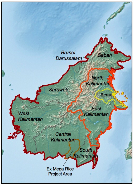
Our projects include research in East & North Kalimantan (projects 1,2,5, in orange), Berau regency within East Kalimantan (projects 2,4, in yellow), and the Ex Mega Rice Project in Central Kalimantan (project 3, in brown), and we are contributing to the Borneo Futures Project, which is a network of collaborations for research and communication across the island of Borneo.
People
Kerrie Wilson, Elizabeth Law, Sugeng Budiharta, Jessie Wells, Rebecca Runting
Key collaborators
Erik Meijaard, Hugh Possingham, Brett Bryan, Oscar Venter, Marc Ancrenaz, Nicola K Abram, Lex Hovani
Research Themes
Ecosystem services and biodviersity conservation
Research Sites and Projects:
- East & North Kalimantan – Projects 1, 2, 5
1. Optimal allocation of restoration investment across multiple ecosystems
2. Integrating watershed ecosystem services into landscape planning
5. Using multiple zones to plan for conservation in production landscapes
- Berau – Projects 2, 4
2. Integrating watershed ecosystem services into landscape planning
4. Planning for REDD+ in Berau, East Kalimantan
- Central Kalimantan – Project 3
3. Trading-off carbon, biodiversity, and livelihoods in Central Kalimantan
______________________
Example Projects
______________________
1. Optimal allocation of restoration investment across multiple ecosystems
Using East Kalimantan as a case study, we are prioritising degraded forest for restoration and determining which restoration actions should be implemented across multiple ecosystem types, ranging from mangrove forest to montane forest. We are developing a forest restoration scenario that will be simulated using a combination of non-spatial and spatially explicit optimization algorithms. We will use a simulated annealing algorithm to optimize ‘where’ different restoration actions should occur with the objective to minimize the overall costs of restoration while achieving pre-defined targets for each restoration action. The targets for each restoration action will be determined using an exhaustive search algorithm to determine ‘how much’ of each restoration action should be allocated to ‘which’ restoration zones, in order to maximize the recovery of features (i.e. carbon sequestrated and mammal habitat restored) given particular levels of resources (e.g. budget, area extent).
Articles based on this project are currently in development, for more information please contact Sugeng
![Lianas ascending to the canopy in Kalimantan's tropical rainforest Photo: Mattias Klum, National Geographic [ link: http://ngm.nationalgeographic.com/geopedia/Borneo ]](https://wilsonconservationecology.com/wp-content/uploads/2013/09/kalimantan-rainforest-lianas-trees_natgeo.png)
____________________________________________________
2. Integrating watershed ecosystem services into landscape planning:
This project quantifies flows and benefits from water-related ecosystem services, and incorporates these services into spatial planning, together with objectives for development and biodiversity. These ‘water-related ecosystem services’ encompass the supply of freshwater(its quantity, quality and timing), prevention or mitigation of damage from water flows (e.g. flooding, erosion), and regulating movement of sediments or nutrients, and the study considers three spatial scales: Kelay-Segah watersheds, Berau river basin, and East Kalimantan.
Specifically, this project aims to:
1. Quantify hydrologic ecosystem services in relation to land-use and climate change, to understand the full path of services from ecosystems to beneficiaries,
2. Integrate ecosystem service flows into spatial land-use plans to achieve multiple objectives for biodiversity, ecosystem services, and development; and
3. Quantify the ‘value of information’ offered by more complex analyses, finer spatial scales and alternative data sources – from estimation of ecosystem services, through to resulting decisions.
If you would like to find out more about this project, please contact Jessie
Wells, J.A., Meijaard, E., Abram, N.K. & Wich, S.A. (2013). Forests, Floods, People and Wildlife on Borneo.
United Nations Environment Program, Nairobi, Kenya.
Meijaard, E., N. K. Abram, J. A. Wells, A.-S. Pellier, M. Ancrenaz, D. L. A. Gaveau, R. K. Runting, and K. Mengersen. (2013). People’s perceptions on the importance of forests on Borneo. PLoS ONE 8 (9) e73008 View online

____________________________________________________
Conserving biodiversity and ecosystem services in the context of REDD+ and other emerging carbon initiatives
Initiatives to reduce the release of greenhouse gases are providing increasing incentives for conservation and sustainable land management. REDD+ is one of the key initiatives that is currently emerging in tropical regions (REDD+ stands for Reducing Emissions from Deforestation and Degradation, ‘plus’ conserving, sustaining or enhancing forest carbon stocks). The consequences for biodiversity and communities will depend on the tradeoffs and synergies among emissions reductions, other ecosystem services, and biodiversity conservation, and how the costs and benefits are shared across actors. Indonesia has large tracts of forests that are experiencing heavy exploitation and conversion to agricultural land uses. If planned and managed well, REDD+ and wider low-carbon development initiatives could provide important protections and incentives to help reverse this trend, reduce greenhouse gas emissions, and contribute to sustainable development.
_______________
3. Trading-off carbon, biodiversity, and livelihoods in Central Kalimantan
Land use planning is a complex task, made even more so with competing objectives in multifunctional landscapes and multiple stakeholder groups. The Ex Mega Rice Project area in Central Kalimantan, Indonesia, is no exception. Largely overlaying substantial lowland tropical peat, past land use change has resulted in this region being a significant source of carbon emissions as the peat degrades. High poverty rates are common, and agricultural development is a key objective for the area, including significant expansion of oil palm. Further, the region is home to many threatened primates, including orangutan, and underrepresented ecosystem types such as lowland peat swamp forest.
Our overarching goal for this project is to answer the question: Can a land use plan be developed that will simultaneously satisfy all the management objectives? If so, what will it look like? If not, what are the trade-offs?
Our research, led by Elizabeth Law, has mapped the value of five ecosystem services (agriculture, oil palm, forestry, carbon, and biodiversity) across the study region. We define how different land use options affect each ecosystem service, and evaluate the performance of current management and existing land use plans to satisfy the targets for each service. We then apply multi-objective optimisation to evaluate the appropriateness of stated planning targets, and use this model to suggest development strategies that may help achieve them.
Law EA, Meijaard E, Bryan BA, Mallawarachchi T, Koh LP, Wilson KA (In press). Better land-use allocation outperforms land sparing and land sharing approaches to conservation in Central Kalimantan, Indonesia. Biological Conservation.
Law EA, Bryan BA, Torabi N, Bekessy SA, McAlpine CA, Wilson KA (In press). Measurement matters in managing landscape carbon. Ecosystem Services. Online early. DOI. 10.1016/j.ecoser.2014.07.007
*Law EA, Bryan BA, Meijaard E, Mallawarachchi T, Struebig M, Wilson KA (2015) Ecosystem services from a degraded peatland of Central Kalimantan: implications for policy, planning, and management. Ecological Applications. 25, 70-87
![Peat forest in Central Kalimantan in March 2013. Photo by Rhett A. Butler www.mongabay.com [Note on copyright - free for educational and non-commercial use, unaltered, and with acknowledgement]](https://wilsonconservationecology.com/wp-content/uploads/2013/09/peat-forest-and-river-central-kalimantan_rhettbutler_mar2013_mongabay.png)
______________________________
4. Planning for REDD+ in Berau, East Kalimantan
The Nature Conservancy are working with indigenous communities, governments and companies to develop a REDD+ program in Berau regency (22,000 km2). The program aims to reduce emissions from forest lands and catalyze sustainable development through a diverse array of strategies, including reduced-impact logging, sustainable livelihoods programs, land swaps (to re-locate planned developments), and establishing or managing protected areas.
Our research aims to assess the effectiveness of these alternative strategies, and to prioritize alternative REDD interventions across the landscape – identifying what to do, and where, in order to achieve objectives for carbon, economic development and biodiversity. This enables us to incorporate several forms of ecological and social information, and to assess the trade-offs or dependencies among these objectives, to help in designing an effective and equitable REDD+ program.
Venter, O., Possingham, H.P., Hovani, L., Dewi, S., Griscom, B., Paoli, G., Wells, P., Wilson, K.A., 2013. Using systematic conservation planning to minimize REDD+ conflict with agriculture and logging in the tropics. Conservation Letters 6, 116-124 View online: http://onlinelibrary.wiley.com/doi/10.1111/j.1755-263X.2012.00287.x/full
Venter, O., E. Meijaard, H. Possingham, R. Dennis, D. Sheil, S. Wich, and K. Wilson. 2009. Carbon payments as a safeguard for threatened tropical mammals. Conservation Letters 2:123-129. doi: 10.1111/j.1755-263X.2009.00059
Venter, O, Wilson, K, Meijaard, E. 2008. Strategies and alliances needed to protect forest from palm-oil industry. Nature 451, 16. doi:10.1038/451016a
____________________________________________________
5. Conservation planning with multiple zones in production landscapes
We developed methods to prioritise investments in alternative conservation strategies across East and North Kalimantan, accounting for the relative contributions that a range of different land uses can make to conservation, from production forest to well-managed protected areas. We employed data on the distribution of mammals (from a collaboration with Luigi Boitani and Carlo Rondinini at The University of Rome) and assigned species-specific conservation targets to achieve equitable protection by accounting for life history characteristics and home range sizes. We found that traditional planning approaches (i.e. assuming each area either protects biodiversity completely, or not at all) would have overestimated the cost of achieving the conservation targets by an order of magnitude. Our approach revealed not only where to invest, but which strategies to invest in, in order to effectively and efficiently conserve mammal biodiversity in East Kalimantan.
Wilson, K. A., E. Meijaard, S. Drummond, H. S. Grantham, L. Boitani, G. Catullo, L. Christie, R. Dennis, I. Dutton, A. Falcucci, L. Maiorano, H. P. Possingham, C. Rondinini, W. Turner, O. Venter, and M. Watts. 2010. Conserving Biodiversity in Production Landscapes. Ecological Applications. 20:1721-1732. doi:10.1890/09-1051.1
Drummond, S. P., K. A. Wilson, E. Meijaard, M. Watts, R. Dennis, L. Christy, and H. P. Possingham. 2010. Influence of a threatened species focus on conservation planning. Conservation Biology 24:441-449 doi: 10.1111/j.1523-1739.2009.01346.x.

You must be logged in to post a comment.